


loading…
Images collected by various satellites show major cities and population centers across the East Coast of the United States (US) are sinking. Photo/Laboratory Equipment/NASA
NEW YORK – Images collected by various satellites show large cities and population centers across the East Coast of the United States (US) are sinking. Soil sinking, or subsidence, is very dangerous because it can damage building foundations and potentially cause collapse.
The hardest hit cities were New York City, Long Island, Baltimore, Virginia Beach, and Norfolk. These cities experience land subsidence more rapidly compared to areas that sink more slowly.
This condition poses a risk to infrastructure such as roads, building foundations, pipeline networks, railway lines, and even airport runways. It can also damage roads and gas and water lines.
When combined with rising sea levels caused by climate change, land subsidence in coastal areas can increase the risk of flooding. This threat can worsen the damage that has occurred.
New research from Virginia Tech and the US Geological Survey (USGS) shows that some areas of the US East Coast are sinking as fast as 5 millimeters (0.2 inches) per year. The rate of land subsidence on the edge of the Atlantic Ocean exceeds the limit of land subsidence.
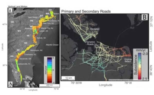
“Continuous and unmitigated land subsidence on the US East Coast should raise concerns,” said Leonard Ohenhen, research and graduate student at the Virginia Tech Earth Observation and Innovation Lab, quoted by SINDOnews from the Space page, Friday (5/1/2024 ).
Together with Professor Manoochehr Shirzaei of the Virginia Tech Earth Observation and Innovation Lab, Ohenhen and colleagues collected large amounts of data from space-based radar satellites to create digital terrain maps.
They then measured millions of subsidence events over many years. It then followed up by creating some of the first high-resolution images of submerged land.
The team’s maps show that large areas of the US East Coast are sinking at least 2 mm (0.08 in) per year. In addition, scientists also found that areas along the mid-Atlantic coast, covering an area of more than 3,626 square kilometers, experienced a decrease of 5 mm (0.2 in) per year or more. Even though the current rate of global sea level rise is around 4 mm (0.16 in) per year.
“We measured a subsidence rate of 2 millimeters per year impacting more than 2 million people and 800,000 properties on the East Coast. “We know to some extent that the land is sinking,” Shirzaei said.
(wib)
